 |
| Chose route B140 over A1 from Geelong to Warrnambool as this will be the fastest option as it has less traffic and does not pass through bigger towns. The following day will be travelling to Geelong and onwards to Melbourne on Route B100, The Great Ocean Road. |
 |
| This is a Typical Aussie McDonald's. R&R area along the Princes Highway somewhere near Werribee. They all have a section called McCafe, which serves fancy drinks, in competition with the likes of Coffee Bean, Starbucks and the like. Thailand has similar set-up but Malaysia has yet to catch-up. |
 |
| Put up a night at Mahogany Motel in Warrnambool in order to have an early start to travel the whole length of the Great Ocean Road (243 km between the towns of Warrnambool on the west and Torquay on the east) and ending up back in Melbourne. A total of 350kms. |
 |
| Yummy... 'Fish n Chips' for dinner. Wonderful fried white fish fillets, thick aussie potato chips, tomato and tartare sauce! Heaven... |
 |
| Full moon at dusk. Warrnambool is famous for its whale watching (southern right whale) during winter, where they can be viewed from the beach on a specially built platform at Logan's Beach. They come here to give birth and nurse their calves. Alas, none sighted while we were there, although a female did appear a couple of days before we arrived. |
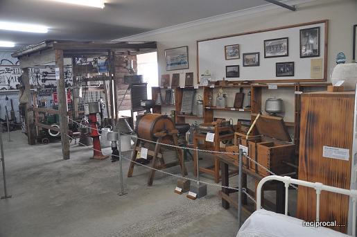 |
| Museum at Allansford Cheese World. Historical farm implements over the years. |
 |
| Big and tiny islands. |
 |
| Natural rock formation along the Great Ocean Road. Formed by wind and water erosion over million of years. |
 |
| Dangerously high cliffs with beautiful clear sea below. |
 |
| Hardy shrubs typical for the area due to the harsh weather. |
 |
 |
 |
 |
| Beautiful beach. Wonder if there is access to it. Looks like it is landlocked. |
 |
 |
| Ample warnings to all visitors. |
 |
| One of the formed islands. |
 |
| On close up, it provide accommodation and breeding ground for many types of sea birds. Rather precariously though! |
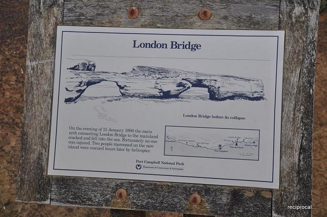 |
| An interesting history about the 'London Bridge' rock formation and a sketch of what it looked like before a portion of it collapsed. |
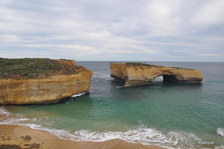 |
| What it looks like now. No longer a bridge. |
 |
| The quaint little town of Port Campbell. |
 |
| Another view of Port Campbell. Quiet and clean beach. |
 |
| The information centre at the Port Campbell National Park which is the main entrance for viewing the Twelves Apostles. |
 |
| The path leading to the viewing platform. This place is a major tourist attraction. |
 |
| The main entrance to the viewing area. |
 |
| Nicely camouflaged speakers. Blends well with the surroundings. |
 |
| One of the viewing decks. Photography session anyone? |
 |
| The Twelve Apostles. Try as I may, even from many angles, they do not add up to twelve! I presumed some had crumbled into the ocean. |
 |
 |
| A view of the so called boardwalk and viewing platforms. |
 |
| Another angle. Just try and count... |
 |
| Chilling reminder. |
 |
 |
 |
| Nice spot to rest and just soak in the view. The rock formations are visible on both sides. |
 |
| It was pretty crowded. |
 |
| Lovely countryside. |
 |
| Great spot to build a home. Elevated view of the Southern Ocean. |
 |
| Rolling hills with grazing sheeps. Somewhere near the town of Apollo Bay. |
 |
| Grazing land. |
 |
| A nice holiday home in Kennett River. Notice the solar panels for hot water system. |
 |
In Kennett River, if you look up the trees and search, you will be rewarded with a view of wild koalas in their natural habitat. |
 |
| Koalas. Spent most of their time on their favourite pastime....zzzzzzzzz. |
It was getting dark by this time and the temperature had dropped lower, so we headed straight to Melbourne, passing through small holiday towns of Lorne, Anglesea and Torquay before reaching Geelong. The road hugged the seaside but it was too dark for any photographs.
No comments:
Post a Comment